

Animace vrstev Země.
Nový výzkum vedený univerzitou v Cambridge je prvním, který získal podrobný ‚snímek‘ neobvyklé kapsy horniny v mezní vrstvě se zemským jádrem, asi tři tisíce kilometrů pod povrchem.
Tajemná oblast skály, která se nachází téměř přímo pod Havajskými ostrovy, je jednou z několika oblastí s velmi nízkou rychlostí – nazývá se tak proto, že se zemětřesné vlny při průchodu zpomalují.
Výzkum zveřejněný v časopise 19. května 2022 Příroda komunikaceje první, která podrobně odhaluje složitou vnitřní asymetrii jedné z těchto enkláv a vrhá světlo na hluboké vnitřní krajiny Země a procesy v nich fungující.
„Ze všech nejhlubších vnitřních rysů Země je toto nejúžasnější a nejkomplexnější.“ – jako já
„Ze všech hlubokých vnitřních rysů Země je toto nejfascinující a nejkomplexnější. Nyní jsme získali první solidní důkazy, které ukazují její vnitřní strukturu – je to skutečný mezník v hluboké seismologii,“ řekl vedoucí autor Zhi Li, doktorand. na katedře věd o Zemi v Cambridge. zem“.
Vnitřek Země je tvořen jako cibule: ve středu je železo-niklové jádro, obklopené silnou vrstvou známou jako plášť, a nad tím tenká vnější kůra – kůra, na které žijeme. Přestože je plášť pevný kámen, je dostatečně horký, že teče velmi pomalu. Vnitřní konvekční proudy přivádějí teplo na povrch, způsobují pohyb tektonických desek a podporují sopečné erupce.
Vědci používají seismické vlny ze zemětřesení, aby „viděli“, co je pod zemským povrchem – ozvěny a stíny těchto vln odhalují radarové snímky hlubokého nitra. Ale až donedávna byly „obrázky“ struktur na rozhraní jádra a pláště, což je oblast primárního zájmu pro studium vnitřního tepelného toku naší planety, zrnité a obtížně interpretovatelné.
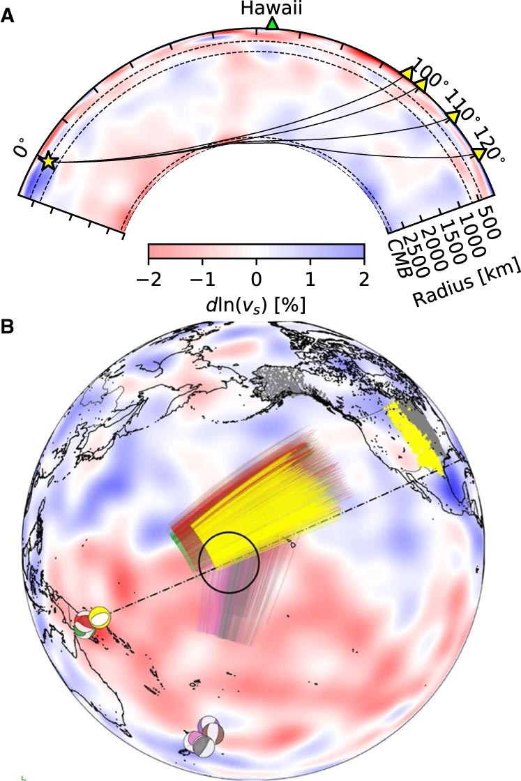
Události a trajektorie paprsků Sdiff použité v této studii. a) Průřez procházející středem oblasti ultranízké rychlosti na Havaji, ukazující trajektorie paprsků pro vlny Sdiff při 96°, 100°, 110° a 120° pro 1D PREM model Země. Přerušované čáry shora dolů označují diskontinuity 410 km, 660 km a 2 791 km (100 km nad hranicí jádra a pláště). b) Události a trajektorie paprsků Sdiff na modelu tomografického pozadí SEMUCB_WM1 v hloubce 2791 km. Plážové míče pro akce natřené různými barvami, včetně 20100,320 (žlutá), 20111214 (zelená), 20120417 (červená), 20180910 (fialová), 20180518 (hnědá), 20181030 (růžová), 2016112 (graytriangle) stanic a paprsky. Trajektorie vln Sdiff v hloubce otvoru 2791 km ve spodním plášti použité v této studii. Událost použitá v krátkodobé analýze je zvýrazněna žlutě. Navržené umístění ULVZ je znázorněno černým kroužkem. Přerušovaná čára ukazuje průřez nakreslený v A. Credit: Nature Communications, DOI: 10.1038/s41467-022-30502-5
Vědci použili nejmodernější metody numerického modelování k detekci struktur v měřítku kilometrů na hranici jádra a pláště. Podle spoluautora Dr. Kuangdai Lenga, který vyvinul metody, zatímco na[{“ attribute=““>University of Oxford, “We are really pushing the limits of modern high-performance computing for elastodynamic simulations, taking advantage of wave symmetries unnoticed or unused before.” Leng, who is currently based at the Science and Technology Facilities Council, says that this means they can improve the resolution of the images by an order of magnitude compared to previous work.
The researchers observed a 40% reduction in the speed of seismic waves traveling at the base of the ultra-low velocity zone beneath Hawaii. This supports existing proposals that the zone contains much more iron than the surrounding rocks – meaning it is denser and more sluggish. “It’s possible that this iron-rich material is a remnant of ancient rocks from Earth’s early history or even that iron might be leaking from the core by an unknown means,” said project lead Dr Sanne Cottaar from Cambridge Earth Sciences.

Conceptual cartoons of the Hawaiian ultra-low velocity zone (ULVZ) structure. A) ULVZ on the core–mantle boundary at the base of the Hawaiian plume (height is not to scale). B) a zoom in of the modeled ULVZ structure, showing interpreted trapped postcursor waves (note that the waves analyzed have horizontal displacement). Credit: Nature Communications, DOI: 10.1038/s41467-022-30502-5
The research could also help scientists understand what sits beneath and gives rise to volcanic chains like the Hawaiian Islands. Scientists have started to notice a correlation between the location of the descriptively-named hotspot volcanoes, which include Hawaii and Iceland, and the ultra-low velocity zones at the base of the mantle. The origin of hotspot volcanoes has been debated, but the most popular theory suggests that plume-like structures bring hot mantle material all the way from the core-mantle boundary to the surface.
With images of the ultra-low velocity zone beneath Hawaii now in hand, the team can also gather rare physical evidence from what is likely the root of the plume feeding Hawaii. Their observation of dense, iron-rich rock beneath Hawaii would support surface observations. “Basalts erupting from Hawaii have anomalous isotope signatures which could either point to either an early-Earth origin or core leaking, it means some of this dense material piled up at the base must be dragged to the surface,” said Cottaar.
More of the core-mantle boundary now needs to be imaged to understand if all surface hotspots have a pocket of dense material at the base. Where and how the core-mantle boundary can be targeted does depend on where earthquakes occur, and where seismometers are installed to record the waves.
The team’s observations add to a growing body of evidence that Earth’s deep interior is just as variable as its surface. “These low-velocity zones are one of the most intricate features we see at extreme depths – if we expand our search, we are likely to see ever-increasing levels of complexity, both structural and chemical, at the core-mantle boundary,” said Li.
They now plan to apply their techniques to enhance the resolution of imaging of other pockets at the core-mantle boundary, as well as mapping new zones. Eventually, they hope to map the geological landscape across the core-mantle boundary and understand its relationship with the dynamics and evolutionary history of our planet.
Reference: “Kilometer-scale structure on the core–mantle boundary near Hawaii” by Zhi Li, Kuangdai Leng, Jennifer Jenkins and Sanne Cottaar, 19 May 2022, Nature Communications.
DOI: 10.1038/s41467-022-30502-5

Přátelský webový obhájce. Odborník na popkulturu. Bacon ninja. Tvrdý twitterový učenec.
